Log in
All resources
Create a design
778 Free Artworks of 1870 Maps
jacob kuyper
gemeente atlas van nederland - drenthe
gemeente atlas van nederland - utrecht
gemeente atlas van nederland - zeeland
gemeente atlas van nederland - south holland
1860s maps of south holland
netherlands in the 1860s
maps from the earth and its inhabitants, vol. iv
charles eugène perron
maps of borger-odoorn
nouvelle géographie universelle, vol. xii
charles eugène perron
gemeente atlas van nederland - limburg
19th-century maps of maastricht
topographischer atlas der schweiz
old maps of fribourg
gemeente atlas van nederland - north holland
egmond-binnen
gemeente atlas van nederland - zeeland
kreekrakdam
eran laor cartographic collection
edward weller
gemeente atlas van nederland - drenthe
maps of borger-odoorn
maps from the earth and its inhabitants, vol. xiv
1870s maps of new zealand
1866 in the netherlands
maps of almelo
gemeente atlas van nederland - zeeland
maps of polders in zeeland
gemeente atlas van nederland - zeeland
maps of polders in zeeland
gemeente atlas van nederland - south holland
maps of lange ruige weide
ismailïa. a narrative of the expedition to central africa for the suppression of the slave trade (1874)
1874 maps of africa
gemeente atlas van nederland - gelderland
maps of ophemert
gemeente atlas van nederland - south holland
maps of zuidland
gemeente atlas van nederland - drenthe
maps of aa en hunze
gemeente atlas van nederland - south holland
1860s maps of south holland
kobe foreign settlement
old maps of kobe
maps from the earth and its inhabitants, vol. ix
1870s maps of jerusalem
maps from the earth and its inhabitants, vol. viii
1870s maps of india
maps from the earth and its inhabitants, vol. ix
1870s maps of jerusalem
maps from the earth and its inhabitants, vol. viii
1870s maps of india
gemeente atlas van nederland - zeeland
maps of polders in zeeland
gemeente atlas van nederland - utrecht
maps of oudewater
gemeente atlas van nederland - zeeland
maps of polders in zeeland
géographie générale; physique, politique et économique (1876)
1870s maps of germany
gemeente atlas van nederland - overijssel
netherlands in the 1860s
gemeente atlas van nederland - friesland
old maps of leeuwarden
19th-century maps of the black sea
1870s maps of the caucasus
gemeente atlas van nederland - utrecht
jacob kuyper
gemeente atlas van nederland - groningen
old maps of groningen (city)
topographischer atlas der schweiz
mur (dit) d'hannibal
old maps of amersfoort
hoogland
maps from géographie illustrée de la france et de ses colonies
orientalist painting
gemeente atlas van nederland - utrecht
vreeswijk
gemeente atlas van nederland - utrecht
maps of nieuwegein
proletarian literature
maps of gennevilliers
gemeente atlas van nederland - zeeland
bommenede
gemeente atlas van nederland - friesland
maps of achtkarspelen
1870 drawings by félicien rops
symbolism,decadent movement
maps from the earth and its inhabitants, vol. vii
charles eugène perron
gemeente atlas van nederland - drenthe
old maps of coevorden
maps of aa en hunze
anloo
zeist in the 19th century
maps of zeist
19th-century maps of the western mediterranean
alfred le petit
maps from the earth and its inhabitants, vol. vii
agricultural maps of china
maps in the library of congress
1877 maps of the united states
maps from the earth and its inhabitants, vol. xiv
1870s maps of australia
maps from the earth and its inhabitants, vol. xv
1870s maps of quebec
maps from the earth and its inhabitants, vol. v
1870s maps of finland
maps from the earth and its inhabitants, vol. xiv
1870s maps of australia
maps from the earth and its inhabitants, vol. x
1870s maps of egypt
maps from the earth and its inhabitants, vol. xvi
1870s maps of mexico
maps from the earth and its inhabitants, vol. xi
1870s maps of algeria
maps from the earth and its inhabitants, vol. xv
1870s maps of quebec
maps from the earth and its inhabitants, vol. xi
1870s maps of tunisia
maps from the earth and its inhabitants, vol. vii
1870s maps of china
department of american paintings and sculpture, metropolitan museum of art
drawings by daniel huntington
maps of landgraaf
rimburg
gemeente atlas van nederland - utrecht
maps of bunnik
maps in the library of congress
1877 maps of the united states
gemeente atlas van nederland - south holland
maps of heenvliet
gemeente atlas van nederland - utrecht
maps of ijsselstein
gemeente atlas van nederland - utrecht
maps of abcoude
maps of borger-odoorn
valthe
maps from the earth and its inhabitants, vol. xi
old maps of the sahara
gemeente atlas van nederland - north brabant
maps of oss
new york and brooklyn, with jersey city and hoboken water front
maps in the library of congress
history of alphen aan den rijn
maps of aarlanderveen
hoogheemraadschap van rijnland
maps of woubrugge
gemeente atlas van nederland - drenthe
maps of borger-odoorn
gemeente atlas van nederland - drenthe
maps of aa en hunze
equestrian statue of napoléon in lyon
19th-century photographs of lyon
equestrian statue of napoléon in lyon
19th-century photographs of lyon
maps from the earth and its inhabitants, vol. vi
population density maps of russia
maps of aa en hunze
gieten
gemeente atlas van nederland - drenthe
maps of borger-odoorn
everett d. graff collection of western americana
maps by g. w. & c. b. colton & co.
jonathan sauter
max bach
maps from the earth and its inhabitants, vol. iv
ecclesiastical maps
old maps of vilnius
vasiliy griaznov
fourrure et pelletiers. a travers les ages
furriers in paris
19th-century maps of the mediterranean sea
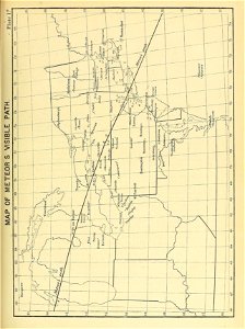
the bottom of the sea (1870)
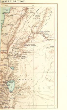
old maps of the sea of galilee
french-language maps
topographischer atlas der schweiz
palügletscher
1870s maps of the caucasus
g. h. swanston
maps from the earth and its inhabitants, vol. iv
falkirk
maps from the earth and its inhabitants, vol. vii
charles eugène perron
equestrian statue of napoléon in lyon
19th-century photographs of lyon
gemeente atlas van nederland - drenthe
maps of de wolden
maps from the earth and its inhabitants, vol. iv
topographic maps of ireland
old maps of twente
delden, overijssel
maps from the earth and its inhabitants, vol. iv
linguistic maps of the united kingdom
maps from the earth and its inhabitants, vol. ix
maps of south india
maps of weather and climate of the united kingdom
maps from the earth and its inhabitants, vol. iv
proletarian literature
maps of gennevilliers
eran laor cartographic collection
william dickes
gemeente atlas van nederland - limburg
old maps of venlo
engravings from the adventures of three englishmen and three russians in south africa by françois pannemaker
illustrations from the adventures of three englishmen and three russians in south africa by jules férat
science
maps
301 - 400 of 778
Next page
/ 8